Mount Kelimutu
Mount Kelimutu
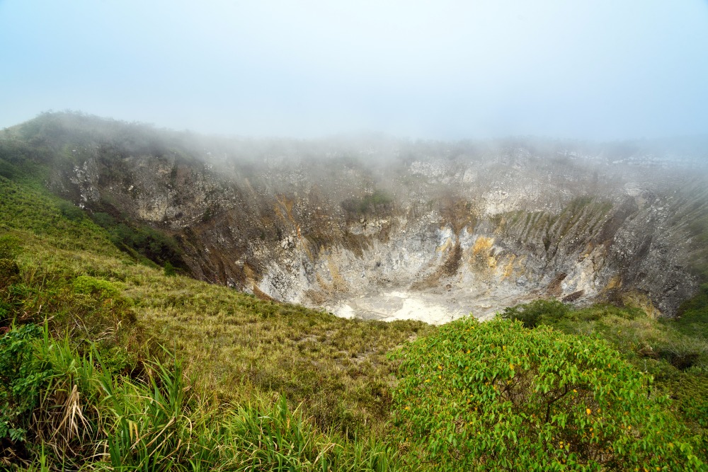
On the island of Flores, Mount Kelimutu rises to 1,639 meters and harbors three volcanic lakes with distinctive hues, sacred to the Lio communities.
On the island of Flores, in the Lesser Sunda Islands, Mount Kelimutu reaches 1,639 meters and shelters three volcanic lakes of distinct colors at its summit. Its last known eruption dates back to June 1968. Accessible from the village of Moni, the site has become one of Indonesia's most studied geological paradoxes: three neighboring craters, three bodies of water with different hues, changing over the months according to the chemical composition of the waters.
Why visit Kelimutu
Kelimutu's appeal lies in a rare phenomenon. Three crater lakes coexist just hundreds of meters apart, yet each displays its own distinct color—from turquoise green to deep reddish-brown and profound black. Chemical variations (volcanic gases, dissolved minerals, redox processes) cause color shifts over weeks, sometimes years. No other Indonesian volcano presents this configuration.
Beyond the geological wonder, the site is sacred to the Lio inhabitants of Flores, who regard the lakes as the dwelling place of ancestral spirits. It is also a renowned vantage point for sunrise observation, when the first light gradually reveals the three craters from the summit viewpoint.
History and legends of the three lakes
For the Lio communities, the three lakes are far more than natural curiosities: they are resting places for souls, and each crater serves its own purpose.
- Tiwu Ata Mbupu, to the west, is the darkest of the three. According to tradition, it harbors the souls of ancestors and those associated with malevolent spirits.
- Tiwu Nuwa Muri Koo Fai, with its turquoise-green hue, is dedicated to the souls of deceased young people.
- Tiwu Ata Polo, with its deep reddish-brown waters, is separated from the previous lake by a simple earthen ridge. It is linked to the souls of those who committed reprehensible acts.
These beliefs remain vibrant today, with nearby villages still organizing ceremonies to honor the spirits of the lakes.
What you will see on-site
From the high-altitude parking area, a built stairway and short trail lead to the main viewpoint overlooking the three craters. The panorama sweeps across the volcanic chain of central Flores and, on clear days, extends down to the inhabited valleys of the south.
The national park surrounding the volcano protects little-known endemic wildlife. Approximately 19 endangered species have been documented here, including the Flores endemic warbler, Wallace's scops-owl, the Flores flycatcher, the Flores eagle, and the Timor wren-babbler. The vegetation, blending montane forest with open areas, shifts rapidly with altitude.
Practical information
- Summit elevation: 1,639 m
- Access: from Moni village, 10 km by scooter or vehicle to the parking area, then approximately 5 km on foot (marked trail)
- Local guide required from Moni for safety reasons
- Fee: entrance fee for foreign visitors, payable on-site; add a small parking charge
- Visit duration: 2 to 3 hours at the site, excluding transfer time from Moni
- Equipment: hiking boots, headlamp for pre-dawn ascent, windproof jacket (the summit is cool and windy before dawn)
When to visit Kelimutu
The dry season, from May to October, offers the best visibility conditions. The wet season brings mist and low clouds that may obscure the lakes during midday.
Sunrise remains the privileged moment: departing Moni around 4 a.m., arriving at the viewpoint before dawn, then watching the lake colors gradually emerge as light increases. Late afternoons are also rewarding, though clouds tend to appear more frequently.
How to reach Kelimutu
The starting point is the village of Moni, situated approximately 12 km from the volcano. To reach Moni:
- By air: airports at Ende (roughly 50 km away) or Maumere (roughly 100 km away), both served from Bali (Denpasar) and Labuan Bajo
- By road: private vehicle transfers or public buses from Ende or Maumere
The final ascent is done by scooter or vehicle to the high-altitude parking area, then on foot to the viewpoint.
What to see around Kelimutu
The village of Moni, the logistical base for the climb, merits a stop for its warungs, nearby waterfalls, and hot springs. More broadly, Flores unfolds east to west along the Trans-Flores Highway, connecting Maumere to Labuan Bajo.
To extend your journey, you can venture to the Komodo archipelago at the western tip of the island. Discover the island of Komodo and its neighbor, the island of Rinca, both renowned for their dragons.
Frequently asked questions
Frequently asked questions
The variations result from underlying geothermal activity: upwelling of volcanic gases, shifts in mineral concentration (iron, manganese, sulfur), and redox phenomena. Changes may be brief or span several years.
The volcano is classified as active, but its last known eruption occurred in June 1968. The site is regularly monitored by Indonesian authorities and remains open to visitors under normal conditions.
Yes. From Moni village, accompaniment by a local guide is mandatory for safety reasons, particularly for the pre-dawn ascent before sunrise.
Plan for approximately 2 to 3 hours at the site (hiking up, observing the lakes from the viewpoint, hiking down), plus travel time to and from Moni.
The dry season, from May to October, offers the clearest skies and therefore the best conditions for viewing the lake colors at sunrise.
Including Kelimutu in your trip
Kelimutu fits naturally into an itinerary traversing Flores, between Maumere to the east and Labuan Bajo to the west. To craft a bespoke journey blending volcanoes, traditional villages, and the Komodo islands, explore our Indonesia travel ideas.
Interested in this visit?
We can include it in your personalised itinerary.