
Geography of Indonesia
Map of Indonesia
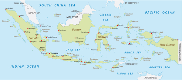
The borders of Indonesia
The Indonesian archipelago shares land borders with Malaysia, Papua New Guinea and East Timor. It is surrounded by the Indian Ocean on the west and the Pacific Ocean on the east. Its interior comprises many seas like the Java Sea, the Banda Sea, the Celebes Sea and the Molucca Sea, to name just a few.The reliefs on the Indonesian archipelago
The terrain of the archipelago presents a variety of patterns with about 150 volcanoes that belong to the Pacific Ring of Fire. But the highest peak is not a volcano. On the Indonesian side of New-Guinea island, a major mountain range exceeding 3,600 meters above sea level stretches from east to west. Mount Puncak Jaya, also called Carstensz Pyramid, culminates the area at 4 884 metres. Apart from rugged relief, plains fill an important portion of the country, especially in Java, Sumatra and Borneo.Indonesia, a volcanically active country
Indonesia’s volcanic activity is one of the highest in the world. Of 150 volcanoes, 70 are active. Mount Merapi in the region of Yogyakarta is one of the most closely monitored volcanoes due to its close proximity to a large urban population.The main islands of the archipelago
Numerous islands and island clusters compose the Indonesian archipelago, each with its own distinct natural environment. We made a list of the main islands to explore when travelling in Indonesia.
Subscribe our newsletters
Azimuth Adventure Travel Ltd is a Western-run and Indonesia-based adventure travel agency, which was set up in 1999. While we specialize in trekking and volcano climbing tours, we have broadened our range of products to allow all nature and culture lovers to get off the beaten tracks and discover an authentic and multicultural Indonesia. Whether you travel solo, on a tailor-made tour or within a small group of travelers, come and explore Indonesia with us!
Azimuth Adventure Travel Ltd is a founding member of Nomadays, an international network of local travel agencies. Enjoy you trip fully together with Indonesia-based travel specialists!